When you get down to it, most folks who are interested in things vintage—whether they’re movie buffs who thrill at the discovery of a film noir or pre-code picture they’ve never before seen, music buffs who have devoted their lives to hearing every note Bix ever recorded, or devotees of vintage fashion, ever on the watch for a belt-back suit from the 1930s or the perfect cloche hat from a decade before—are after a kind of time travel.
Most of us aren’t convinced (though others are certain of it) that life was better in whichever particular era it is that calls to us, it’s just that life was just different then, in small and particular ways that continue to fascinate us, to entice us to look over our shoulders at what is behind us, just barely out of peripheral view.
The estimable Rick Prelinger (if you’re not already familiar with the Prelinger Collection of ephemeral films, check them out at www.archive.org) expressed it nicely in a 2002 SF Weekly profile:
“I’m fascinated with the look of the past. I have an urgent need to form images of what a place looked like in the ’40s or ’50s. What did it smell like? What were people wearing? What [was] people’s body language? Was it noisy or quiet? Was the air smoky?”
But opportunities to directly compare and contrast life as it was then (whenever your preferred “then” might be) with life as it is lived today are few and far between. Those opportunities are largely what this blog is about—what our interest in the (relatively) recent past is all about—and so we share them with the Cladrite Clan whenever we can.
The official New York City web site, NYC.gov, has, bless its heart, created an online city map that not only allows one to search for an aerial view of any address in the city (these are photos commissioned by the city, not satellite photos) and zoom in and out on the photo, but you can also zoom back and forward—in time!
The city commissioned aerial photos several times over the past 80 years, so it’s intriguing to see from above how things have changed over time. And it couldn’t be easier to do, thanks to the city’s efforts.
We looked up Cladrite World Headquarters on the map, and we were able to view our block as it appeared from above in 1924, in 1956, in 1996, and as recently as 2008.
Friends, that’s what we call time travel.
Deroy Peraza, Principal + Creative Director at Brooklyn-based design firm Hyperakt, made very impressive use of the NYC.gov map to create impressive then-and-now comparisons of familiar NYC sites and sights on a page he titled “NYC From Above: 1924 vs. 2008.”
We’ll share a couple of examples below, but you really must check out the site. It’s quite compelling. The pictures below come from the NYC.gov site; the words are Peraza’s.
 |
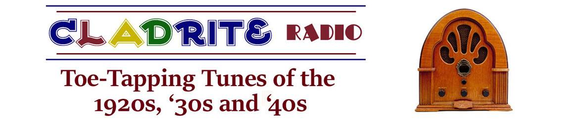
| Yankee Stadium (lower right) was only one year old in 1924. The stadium seen at the upper left is the Polo Grounds, home to the New York Giants (now in San Francisco). The Polo Grounds originally opened in 1890 and had just been renovated in 1923. It was demolished in 1964. |
 |
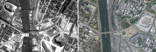
| The waterfront around the Brooklyn and Manhattan Bridges was crowded with ships in 1924. |
We were especially pleased to finally get a sense of where the Polo Grounds were in relation to Yankee Stadium. We knew they were supposed to be close—we’d read that you could see the House that Ruth Built from the Polo Grounds—but we had no idea they were in such close proximity.
We encourage you to check out Peraza’s site and, especially, to make use of the NYC.gov map—but we warn you, it’s addictive.